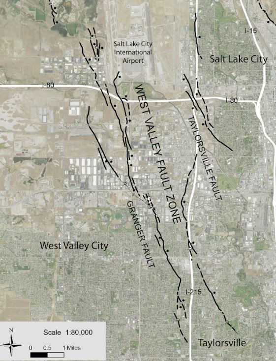
The Utah Geological Survey recently published a geologic map that includes new strands and increased accuracy of the southern parts of the West Valley fault zone, in the middle of the Salt Lake Valley. Previous geologic maps of the area either showed the fault zone in less detail than the new map, or did not show the fault zone at all. Salt Lake City, West Valley City, and Taylorsville will use the new fault mapping for the planning and zoning of future development in rapidly growing areas.
The West Valley fault zone is separate from, but related to the Wasatch fault zone, which is the region’s preeminent fault and lies at the base of the Wasatch Range. “This new mapping provides additional data to scientists studying how the West Valley and Wasatch fault zones are linked,” stated map author Adam McKean. “Research by the Utah Geological Survey shows that the two faults may rupture in tandem, or that an earthquake on the Wasatch fault zone may trigger movement on the West Valley fault zone.” Understanding this connection is an important component for emergency management planning.
McKean used many sources of data combined with fieldwork to create this new geologic map. For example, he used both a 1937 aerial photograph set, one of the oldest in the state, and newly available 3D laser scanning, called lidar, that creates high-resolution land surface images. The study also refined fault locations using data from dozens of fault investigation report shared by cities and local geological consultants in a collaborative database.
No bedrock is exposed in the mapped area, but valley deposits provide insight into Ice Age Lake Bonneville and the rivers that flowed after its demise through the valley and into Great Salt Lake. The lakes and rivers, and their deltas, highlight climate changes of the area over roughly the last 30,000 years.
The Geologic Map of the Salt Lake City South Quadrangle, Salt Lake County, Utah (UGS Map-283DM) is available as a free download. It can be purchased at the Natural Resources Map & Bookstore, located at 1594 West North Temple, Salt Lake City, (801) 537-3320 or 1-888-UTAHMAP, http://mapstore.utah.gov. An interactive geologic map is also available.
The Utah Geological Survey provides timely scientific information about Utah’s geological environment, resources, and hazards.